Fishermans Bend is Australia’s largest urban renewal project, covering about 485 hectares in central Melbourne. The district will consist of five precincts across two municipalities – the cities of Melbourne and Port Phillip – and connect Melbourne’s CBD to Port Phillip Bay. It is expected that by 2050 it will be home to about 80,000 residents and provide employment for up to 80,000 people.

Following an extended period of community consultation, the Victorian Government released the Fishermans Bend Vision in September 2016. The next step in planning for the area is the release of the Fishermans Bend Framework, which is supported by a series of expert background reports. Public consultation will take place on the framework and associated planning controls – further details are at www.fishermansbend.vic.gov.au

Following this is the development of five precinct plans that will detail how the strategies in the framework will be applied to each of the Fishermans Bend neighbourhoods.

EPA’s role in Fishermans Bend

Environment Protection Authority Victoria (EPA) provides comments on the environmental aspects of selected planning applications for proposed developments in Fishermans Bend. EPA is also providing assistance to the Fishermans Bend Taskforce with some of the background reports.

As part of this, EPA has overseen groundwater studies across Fishermans Bend since 2015.

Groundwater studies in Fishermans Bend

The Fishermans Bend groundwater studies were conducted between 2015 and 2017, across the five precincts of Fishermans Bend, as part of the proposed redevelopment. The studies focused on confirming the depth of groundwater and the regional groundwater quality. The studies aimed to understand the regional groundwater quality, and therefore did not focus on specific sources of contamination. Some contamination was identified that will need further assessment through the audit system or as part of EPA’s regulatory role as development proceeds.

In order to make the results of the groundwater studies accessible to all, EPA has produced two plain English documents:

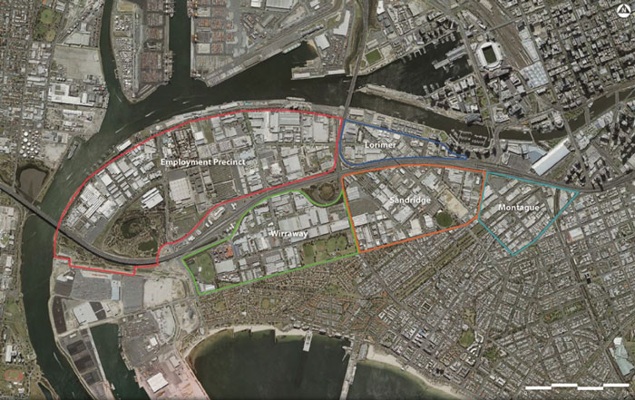
Technical reports for part 1 of the groundwater studies (over the original four precincts; Lorimer, Wirraway, Sandridge and Montague):

Technical reports for part 2 of the groundwater studies (Employment Precinct, and groundwater monitoring event (GME) over all five precincts):

Aerial view of the Fishermans Bend precincts:

Aerial view of the Fishermans Bend precincts

Key planning and environmental legislation and policies that apply in Fishermans Bend

A selection of key planning and environmental protection legislation and guidance documents are as follows:

The environmental challenges at Fishermans Bend

Historical industrial practices often present challenges when planning to develop land for residential and sensitive uses. This is no different with the proposed medium-to-high density residential development at Fishermans Bend.

Victoria’s environmental audit system, in place since 1989, is triggered when there is a change of land use to a more sensitive use, as will be the case with Fishermans Bend. The environmental audit system is used by planning authorities, government agencies and private landowners to determine the condition of a piece of land and its suitability for use, or to determine what’s required to make the land suitable for its intended use. The process is typically applied on a property-by-property basis.

Groundwater investigation is usually undertaken as part of the audit of each property in urban areas. Groundwater quality beyond individual properties is affected by regional-scale infilling (where old waste was used to fill in former swamps to create flat ground – as has occurred historically in Fishermans Bend), as well as past industrial uses conducted in accordance with standards of the time. An extensive investigative approach is needed to develop a complete picture of groundwater across the entire Fishermans Bend area, which is why EPA undertook the studies.

Read next

EPA's programs and projects

EPA's past programs and projects


This page was copied from EPA's old website. It was last updated on 23 August 2019.

  • Why were the groundwater studies done?

    The government saw there was an opportunity with the Fishermans Bend redevelopment to understand groundwater on a larger scale than would be possible through typical property or site-by-site environmental audits.

    The groundwater studies will allow EPA and planning agencies to advise developers within Fishermans Bend on aspects of groundwater management that will require their attention.

    The studies aimed to:

    • determine the precinct-wide baseline groundwater quality, particularly focusing on the shallow groundwater table in contact with fill material (less than 5 m below the ground surface)
    • confirm the protected and precluded beneficial uses of groundwater across the study area
    • understand the potential risk of groundwater contamination to surface water receptors (including the Yarra River and Port Phillip Bay).

    Given the focus was assessment of regional groundwater conditions, specific sites and/or potential point sources of contamination were not targeted during the groundwater studies.

  • How are the protected beneficial uses of groundwater determined?

    The level of groundwater protection in Victoria is based on its natural salinity or the concentration of total dissolved solids (TDS) in the groundwater. For example, the lower the salinity of the water, the more likely the water can be used for different purposes – such as drinking water or for watering plants.

    Refer to the plain English summary of groundwater studies (2015–2017) (PDF 7.1MB) for an explanation of how this applies at Fishermans Bend.

  • How were the studies funded?

    EPA worked with the Metropolitan Planning Authority for the part 1 groundwater study. For part 2, involving the Employment Precinct added to the Fishermans Bend redevelopment area in 2015, EPA worked with the Fishermans Bend Taskforce, which is managing the development of Fishermans Bend.
  • How were groundwater sampling locations chosen?

    Groundwater samples were collected across all five precincts in Fishermans Bend using a probability-based square grid sampling design. This design was chosen as it is unbiased and can be used to define groundwater quality trends over time. The aim was to establish an even spread of wells across the area. Some locations needed to be adjusted because of underground services and/or safety concerns (such as proximity to major roads). Each grid was 250x250m and one well was sampled every six hectares, on average.

    The complete well network consists of 79 wells, which includes 16 pre-existing wells and 63 new wells installed as part of this project. Five of the 63 new wells were installed on private land, which involved consultation with land-owners prior to the works. Owners of pre-existing wells were also consulted prior to sampling. All remaining wells were installed on public land.

  • Is investigation of soil contamination part of the groundwater studies?

    Groundwater was investigated in more detail than soil, as groundwater moves between properties and is therefore more difficult to understand. Limited soil sampling was completed to assist with understanding the potential transport of contaminants between regional infilling, general soil conditions and groundwater quality.
  • How were the studies conducted?

    The studies were completed in stages:

    • A desktop study to document current understanding and data gaps.
    • A safety and stakeholder engagement plan, used during the project to engage with the community on relevant matters and provide project updates.
    • A groundwater sampling analysis and quality plan, determining sampling locations and what potential contaminants would be tested for.
    • Field data collection, including drilling of bores for groundwater sampling following the sampling and analysis plan developed at stage 3, for baseline groundwater quality assessment.
    • Reporting of results.
  • What do the key findings mean for groundwater users in Fishermans Bend?

    Shallow groundwater in Fishermans Bend is not suitable for drinking, nor for watering gardens or filling swimming pools. For all potential uses, it is the bore users’ responsibility to test the groundwater and ensure it is suitable for the intended use.

    EPA is:

    • publishing reports to keep groundwater users in Fishermans Bend informed about groundwater quality
    • meeting with community groups to inform them of the results of the groundwater studies
    • considering a long-term strategy of identifying a groundwater quality restricted use zone (GQRUZ) across the affected area
    • happy to answer any questions you may have regarding groundwater in Fishermans Bend.
  • What do the groundwater studies mean for land-use planning in Fishermans Bend?

    The Capital City Zone planning scheme for Fishermans Bend requires that, before a sensitive development (such as residential use, a childcare centre, preschool centre or primary school) or use for agriculture or public open space occurs, a 53X environmental audit (in accordance with Part IXD of the Environment Protection Act 1970) is required from an EPA-appointed environmental auditor.

    Auditors undertaking these audits would be expected to use the groundwater studies to inform their investigation.

    In other circumstances, the responsible authority for land-use planning decisions must satisfy itself that the land is suitable for the intended use.

  • How can the studies be used in site assessments during development?

    The technical reports provide additional information on geology, groundwater level and groundwater quality, which may provide further context when interpreting site-specific environmental assessment results. However, it does not replace or alter existing requirements for environmental assessment as part of the land-use planning process.

    Onsite sources of contamination must be investigated before identifying contaminants as regionally elevated or background levels, in line with current environmental assessment standards.

    Where groundwater is polluted to a level that it cannot be used for its designated beneficial uses under the State Environment Protection Policy (Groundwaters of Victoria) (varied 2002) and it has been managed and cleaned up to the extent practicable (CUTEP), EPA has authority to identify a groundwater quality restricted use zone (GQRUZ) across the affected area.

    EPA and environmental auditors will consider the findings of the groundwater studies, together with site-specific information, when determining CUTEP for individual sites in Fishermans Bend.

  • What does it mean for below-ground construction and maintenance work?

    Ground excavation workers are likely to encounter groundwater in some parts of the study area. The groundwater may also seep into underground services pits.

    Due to the reported groundwater pollution levels, groundwater seeping into excavation or underground services pits needs to be managed according to the state environment protection policies Prevention and Management of Contaminated Land (varied 2013), Groundwaters of Victoria (varied 2002) and Waters of Victoria (varied 2004).

  • How has EPA engaged with the community on the studies?

    EPA Victoria met regularly with the Port Phillip City Council Fishermans Bend Community Forum regularly during the studies, to present on progress and results, and to answer questions.

    Contact us with any questions or concerns.

  • What is the community forum?

    The Port Phillip City Council Fishermans Bend Community Forum is made up of 19 representative groups from the local community, including key residents groups such as the Fishermans Bend Network, Montague Alliance and Community Alliance Port Phillip.

    Members also include representatives of local businesses and landowners, the local heritage group, bicycle users group, a sustainability action committee and others.

  • What is the local councils role in this project?

    The local councils (and road authorities) gave consent to an EPA-appointed consultant, AECOM Australia, to drill and install bores on public land for the groundwater studies. The councils will also play a role in the audit process that comes with proposals for redevelopment of land to a more sensitive use, including when land use changes from industrial to residential.

    General information from the two relevant councils can be found at these web pages:

  • What is groundwater?

    Learn more about groundwater on the land and groundwater page.

Reviewed 10 March 2023